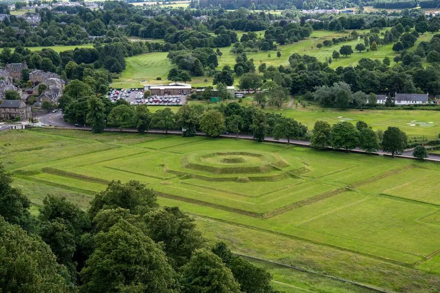
Two different things share a royal name at the foot of Stirling Castle, and visitors mash them together. King’s Park is the municipal park: swings, a café, a skatepark, toilets, tennis, an outdoor gym, and a golf course you are asked not to walk across. The King’s Knot is a Historic Environment Scotland earthwork on the other side of Dumbarton Road: an octagonal stepped mound in the old royal garden, free, always open, and best read from above.
They were one landscape. They are not one visit, and they are not King’s Park in Perth, Western Australia. This is Stirling.
The ground below the castle was a royal hunting park from at least the twelfth century, Crown land attached to the rock, used for hawking, hunting and the sort of display a Stewart court wanted within sight of the walls. The Knot is what remains of the formal garden laid out on that park. The municipal park is what the town now runs on the same historic estate.
You can do both in an hour. You can also do only the swings. The mistake is to stand in the play area and wonder why it does not look like a Renaissance garden, or to stand on the mound and look for a café. The Smith sits on the park’s edge. The castle sits above both. Dumbarton Road is the old west road, not a footpath. Cross it on a crossing.
Stirling Council’s park is at the junction of King’s Park Road and Victoria Place, postcode FK8 2JS. It is free, open year-round, and it is the city’s main green space rather than a visitor attraction with a till.
It is five minutes from the town centre on the flat, and a world away from the castle queues. Locals use it. That is the point. A Saturday here is football, dogs, scooters and the Pavilion, not a timed entry. You do not need the leases. You need to know which grass is the golf course.
The play area is built for mixed ages, with inclusive kit — swings and a wheelchair roundabout among it. Water play runs in the summer months only. The skatepark is concrete, floodlit, and the thing teenagers in Stirling actually use. Stand off the run if you are only looking.
Tennis courts and an outdoor gym sit in the same cluster, with picnic tables, a historic drinking fountain and a small Peace of Mind garden by the play area. The café is the Pavilion: indoor and outdoor seats. Hours follow a café logic, so check rather than counting on breakfast in February. Public toilets are opposite the tennis courts, and they have a local reputation for being in working order.
None of this is why a castle historian comes. It is why a family stays after the Knot. See Stirling with kids.
Most paths have a finished surface and are usable with a pushchair or a wheelchair. There are steeper, informal bits at the edges. The council’s request is simple: stay on the marked paths and do not cross the golf playing area. Stirling Golf Club occupies a large share of the old park.
Parking is free on-street off King’s Park Road. That is parking for the park, not the castle. See parking in Stirling. Dogs are welcome in the park. The golf course is not a dog run.
Waymarked heritage trails run through the park; the map and the stops live at kingsparkstirling.org. Three coloured routes cover the ground:
The Heritage Circuit is about 1.6 km, around 35 minutes, and stays with the amenities and the Victorian layer of the park. The King’s Knot Loop is about 2.9 km, around 70 minutes, and is the one that climbs out to the earthworks and the castle views. A longer perimeter route takes in the old racecourse ground. Combining circuit and Knot loop is the full set of stops, around 5 km.
Some paths are unsealed and sit wet after rain. The trails are a local project, not a ticketed HES tour.
Below the castle rock, off Dumbarton Road, the King’s Knot is a scheduled Historic Environment Scotland site. It is free and open all year. There is no till, no café, no timed entry.
What you are looking at is an octagonal stepped mound about three metres high, with a rectangular parterre to the south-east — the grassed bones of a formal royal garden. It was laid out in 1627–29 for Charles I’s Scottish ‘hamecoming’ and coronation in 1633, on ground that had already been royal garden for more than a century. Queen Victoria had it restored in 1842. The pattern is the point. Up close it is a stepped lawn. From above it is a diagram.
Geophysical survey has found earlier features under the grass, and there is a long, unproven tradition linking the site to a round table. Treat that as folklore unless you are here for the folklore. The documented thing is a seventeenth-century garden of a quality Scotland does not have many of.
You can walk onto the mound. The view from the top is straight up the crag to Stirling Castle. The scale of the garden itself is almost invisible from here, which is why the next section exists.
Do it twice.
From the Ladies’ Lookout on the castle walls, the Knot reads as a whole: octagon, terraces, the Queen’s Knot beside it, the park beyond, the carse flattening towards the Forth. That is the designed view. It is one of the reasons to walk the walls, and it is included in the castle ticket. Our castle guide covers the rest of the rock.
From the mound looking up, you get the castle the way the garden was meant to be seen from below: a palace on a cliff, not a plan on a postcard. The two views do not substitute for each other. The Back Walk along the town wall gives you a third, free, elevated angle without a castle ticket. See walks around Stirling. Late afternoon is the quiet hour on the grass. The earthwork does not close.
The Queen’s Knot sits adjacent, a lower, related earthwork in the same scheme. Together they are the King’s and Queen’s Knots, the last major investment in a royal landscape that had served the court at Stirling from the twelfth century through James VI.
When the court left for London after 1603, the park’s reason for existing went with it. Roads later cut the Knot — Dumbarton Road and the Raploch road took a bite around 1810 — which is why the garden does not meet the crag as cleanly as a reconstruction would. What remains is still one of the best-preserved seventeenth-century garden earthworks in Britain. You are walking a royal estate that became a town amenity. That is the whole Stirling trick, repeated from the castle down.
The Stirling Smith Art Gallery & Museum is on Albert Place, on the park’s edge, and it is free. It holds the city’s art and local history collections, including the oldest football in the world, a sixteenth-century leather ball found in the castle.
It is also the indoor hour that pairs with this outing, and the hours are the fact other guides get wrong. As of the museum’s own site it is open Wednesday to Sunday, 10am–5pm, and closed Monday and Tuesday. Check smithmuseum.scot the week you come. A park day that lands on a Monday is a park day, not a museum day.
The Smith’s café is the wet-weather kettle if the Pavilion is shut. The building is the natural end of the Heritage Circuit.
The shape that works: Smith first, if it is open, then the play area or the Heritage Circuit, then across Dumbarton Road to the Knot. If you have a castle ticket, save the Ladies’ Lookout for the end of the morning on the rock, so the pattern is already in your head. Or do the Knot from the castle walls first, come down through the old town, and finish on the grass — easier on the knees.
A wet day still has the Smith and the Pavilion. The Knot is grass on a plain; it will wait. See Stirling in the rain. Do not confuse this with the Queen Anne Garden on the rock, inside the castle ticket. The Knot is the garden they laid out on the floor of the valley, and it is still there, and it is free.